Trimble Business Center v5.70 Released Today
Trimble announced the release of the much awaited TBC v5.70 yesterday.
This new release has a Warranty date of June 1 2022.
Download Location: Geospatial
Download Location: Construction
Trimble Release Notes:
Click Here to access the Release Notes
Key benefits in this release for contractors include
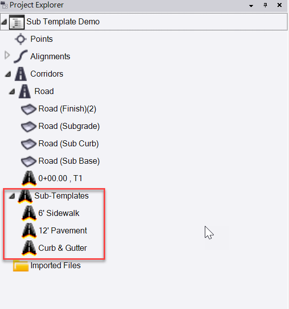
New Sub Templates function for corridor modeling.
This allows you to create sub templates for objects like curb and gutter, barrier walls, pavement surfaces, sidewalks etc. that can then be used within the corridor template using the new sub template instruction type. You can copy and paste sub templates from a master project into a project using RPS Copy to Clipboard and RPS Paste command, or you can save your sub templates out as a VCKL file and drag / drop them into any project. Sub templates can have multiple material layers defined within them allowing you to rapidly model finished grade and subgrade elements.
The Sub Template allows you to significantly reduce the number of instructions required to build a corridor model.
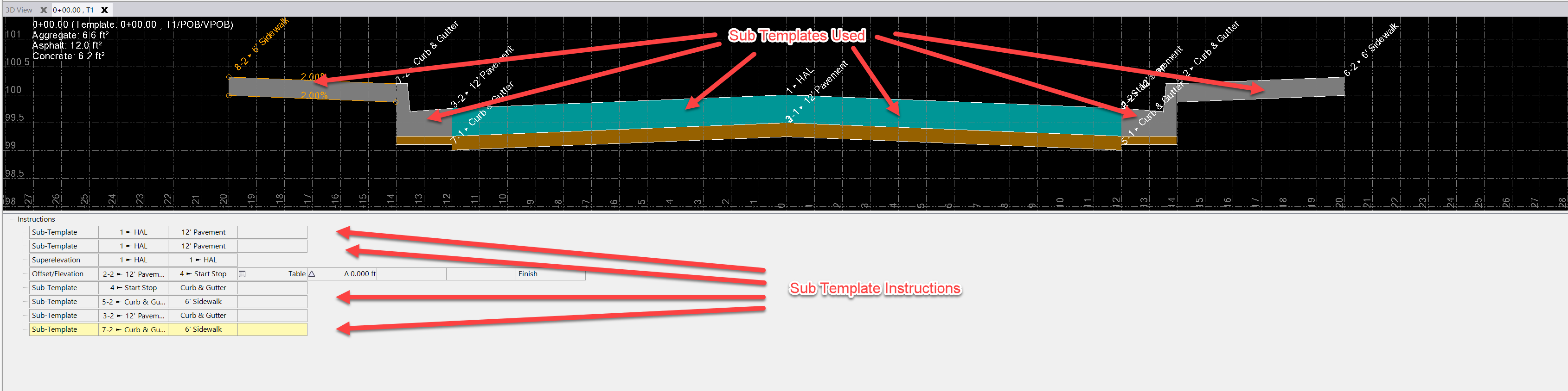

Corridor Surface Models generated from Corridor Defined using Sub Templates
Note: In our testing of the sub template function, the finished grade elements of eg a Pavement material stack will get affected by a superelevation command but not the subgrade surfaces. In addition, there is no way to easily control where a sub template is applied - you need to create a control line in the instruction list that can trigger the start and stop locations for the sub template. Neither of these items are a show stopper, the functionality is a useful addition for certain types of corridor modeling.
New Transition control for corridor template instructions
This allows you to control whether or not a template instruction is allowed to transition between templates. This means that you can now more safely use multiple templates in corridors without having to be so concerned about template transitions occurring inadvertently.

Vector PDF Background Point Snapping
When you import and georeference a PDF file, you can now check a checkbox to enable “Save snap locations”. This creates snappable point locations in the PDF image so that when it is turned on, the nodes on the lines in the PDF image are fully snappable (just like any other snaps on objects in the CAD database.

Takeoff Surface Boundary Definition
When categorizing layers for takeoff, you can now tag a layer as “Contains surface boundaries” in the same way that you tag the layer as having potential site improvement boundaries. This allows you to e.g. use the shrink wrap command to create a boundary around your point and line data and place it on a categorized layer so that it automatically acts as a surface boundary for your existing or design surface models.

Categorize layers dialog

RPS New Layer Dialog Update
This feature has been picked up in the RPS New Layer Command / Control, so that you can make this association when you create the layer for the surface boundary that you are creating. (See RPS Command Library v5.7 release information).
IRI Reporting improvements for surface model checking
We worked with Trimble to improve the IRI reporting functionality in this release. The updated IRI reporting can now more easily be used to validate pavement surface models prior to use on paving machines.
Point Cloud Handling
A couple of great new additions to the point cloud workflows.
- Filter Point Cloud - this allows you to select points in a point cloud using a Station or line / alignment filter allowing you to find points in the point cloud that lie within a given distance / offset left / right or above / below a selected line or alignment. Height based filtering and Radius based filtering around a reference line or scan station setup point is also possible.
- Scan Inspection - this allows you to compare a point cloud to a second point cloud scan, a reference surface or a solid object (IFC solid, CAD Solid) to check as-built information. You can also check a selection of measured points against the solid objects or surface also. The results of the scan inspection are a color rendered set of data that can be color coded with different color map templates.

QA Inspection comparing scan survey with bridge wing wall solid model
This new tool is complemented by the RPS Face Analyzer tool - see RPS Command Library v5.7 release notes (coming shortly).
- Lane marking Feature Extraction Improvements - This feature has been further enhanced to further automate and increase the accuracy of lane marking feature extraction.
Check for Errors in a Works Manager Design
Use the Works Manager Design Status command to see why a design failed to publish to Works Manager without having to log into Works Manager.
Vertical Design Improvements
- A number of improvements have been made to the general use of the Vertical Design command, continuing to improve its performance and capability.
- Vertical Design Rule property (Apply to all crossing lines) that allows a defined rule to affect all lines that it crosses between the from line and to line locations. This applies to the cross slope, cross dz, elevate by slope and elevate by dz rule types.
- New Elevation Line rule that allows you to elevate lines between the source and target lines onto a curved shape based on an input arc radius. This can be used for slope rounding.
New Shrink Wrap Command
This new command allows you to quickly create a boundary line from a selection of point and line objects.
Note that in our testing of this command, the 2D boundary created is good, the 3D boundary when created from contours has incorrect elevations caused by the fact that contours only have a single elevation point at the start of the contour line - this causes the boundary to interpolate elevations along a line that should have constant elevation.
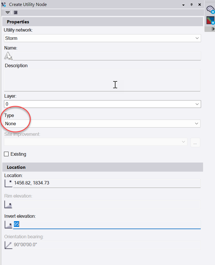
Utility Modeling - Utility Node - Type None
When defining nodes in a utility network, you can now select type None for the utility node. This allows you to specify a location and invert elevation for the location at which a pipe will connect without having to place a block or symbol at the location. This allows you to bring pipes into junction boxes at a specific location other than box center in an easy way.
Photogrammetry / UAS Master Improvements
Numerous improvements have been made to the photogrammetric data processing for Drone captured data. The strength of the TBC application for processing images to point clouds is growing rapidly with each new release.
Layer Manager Improvements
The Layer Manager command now has a Filter control that allows you to enter a layer name filter mask to reduce the list of layers presented in the layer manager.
Import Command Dialog Improvements
The Import command dialog has been changed. You can now apply a filter to the list of files presented from the target folder, allowing you to filter down to just the file types or file names that you are looking for.
Measure Distance Report
When measuring distances using the measure command, you can save the measured distances on a layer. The new measured distance report allows the output of those measured distances (selected from the Project Explorer to a CSV file.
Blocks Automatically Scaled Correctly in Sheet View
With this update, when you place a block in the sheet view, it is automatically scaled in sheet units vs ground units in the plan view.
Grid Volumes Include Balance Factor Information
When you run a grid volume, the results now also contain the change in elevation required to balance the Cut / Fill numbers and the change in volume expected with a 0.1 unit change in elevation.
Tunneling, Mobile Mapping, Monitoring Improvements
These modules are continuing to develop and evolve for these vertical applications. See the release notes for more details.
Rockpile Solutions Custom Menu Configuration for TBC v5.70
The Rockpile Solutions Custom Menu Ribbon has been updated and is now available on the MyRockpile Community for download. This is available to RPS Command Library subscribers only. Please contact us for details. If you are an RPS subscriber, have a MyRockpile Community account, are signed in and cannot access the TBC Libraries and Templates section, please give us a call so we can give you access (or send in a support ticket to Support@RockpileSOlutions.com.
Rockpile Solutions Command Library v5.7 Installation Package
We will shortly release our command library install package for TBC v5.70 - check our website over the next 48 hours to grab that when it becomes available. See RPS Command Library v5.7 Release Information for more details.
Rockpile Solutions Command Library - Version Numbering Update
From now on, at each TBC major release e.g. 5.70, 5.80 etc. we will now release a corresponding RPS Command Library update. All command versions will be updated, regardless of whether or not they have been changed or improved. After the initial release package, command updates will be v5.71, v5.72 etc. until the next TBC update at which point they will update to v5.8. In this way it will be easy to track the correct version to install with each new release of TBC.
The release information associated with the installation package will provide detailed information about what changed in the release.