RPS Command Library v2024.10 - Release Notes
RPS Command Library v2024.10 Releases Today
October 16th 2024
We are pleased to announce the much anticipated release of the RPS Command Library v2024.10 today.
This release contains 4 new commands but inside those commands you will find enormous capability that will radically change the way that you work with Trimble Business Center for Takeoffs and 3D Modeling, dramatically increasing your productivity and your ability to carry out entire work processes in a single command.
As part of our consolidation initiative, through which we are combining multiple TBC functions into key work process step tools, designed to reduce the number of commands that you have to run every day, eliminating key strokes, mouse moves, mouse clicks, and the need to use third party software products to help you execute a task, these new tools streamline the processes of
- Processing PDF Files for Site and Alignment Projects
- Data Prep and 2D / 3D Editing
- Elevating Data
- Modeling Data for Takeoffs and 3D Models
- Reporting and Producing Deliverable Drawings
PDF Manager

Reviewing PDF Files, Importing, Renaming and Tagging PDF Pages, Georeferencing Pages containing Plan and Profile drawings, creating and adding image boundaries, extracting vector data from the PDF pages, managing layers and layer groups, clipping linework to edge match data across multiple sheets, deleting text outside clipping boundaries, cutting images and placing them in your plan view drawing area, and re referencing the PDF Sheets along with all extracted, imported or keyed in data. The tool also provides the ability to compare PDF Page revisions to identify changes (Additions, Removals, and Modifications). One command, huge capability and extremely fast and easy to use for site and alignment based projects.
Quick Preview Video
Site Plans - Multi Sheet Review
Highway Plans - Plan and Profile Sheet Review
New PDF File Reviewer

- Connect your PDF Files and Revisions to your TBC Project
- Group Pages into Page Collections for processing speed
- Name Pages for easy reference
- Review PDF files to identify the sheets required for Existing, Finished Grade, Erosion Control, Demolition, Paving, Phasing / MOT Management and tag ready for production.
New PDF Manager - Georeference

- Automated page loading in clear project space
- Multiple methods to Georeference Sheets including No Scale, Scale, Orientation, Position, Scalebar, Alignment and Multipoint Alignment, Multipoint Coordinate
- Multipoint methods automatically error check with residual error analysis
- Georeference multiple area extracts of the same sheet in different locations of the project e.g. for driveways, intersections, cul-de-sacs etc.
- Georeference Plan and or Profile Drawings
- Automated image boundary creation using Rectangle, Polygon or Alignment methods (Matchlines and Offsets to alignment) - Image boundaries are used to AutoCrop extracted vector data from the images
- Vector and COGO snaps are available throughout the process allowing you to precisely locate your sheets, especially helpful with multi sheet projects. Better edge matching and automated clipping facilitate much faster Data Prep and 3D Modeling processes down stream.
New Irregular Sheet Boundaries - Great Edge Matching!

New Data Extractor - Vectorization

- Advanced data extraction methods that allow you to select what types of data to extract (Solid Lines, Dashed Lines, Fills and Text), how to manage the Layers and Layer Groups for the extracted data, how to assign colors to the extracted data for easy and consistent visual reference. Review what is in the PDF Page(s) before you commit to data extraction.
- Layer data using layer prefix, use the PDF Layers if present, Layer by object style if no PDF layers are available, extract all data onto a single layer for revision review to identify changes between revisions quickly and easily.
- Color the extracted data using the colors in the PDF (colored PDF files), Allocate an intelligent color palette to the types of data being extracted, Color more simply based on the object type or override the Bylayer color using a specified color for all lines being extracted.
- Group the extracted data layers into logical layer groups for faster data review after extraction and better view filter controls.
- Better Edge Matching using RPS AutoCrop technology for faster data prep and takeoff activities

Automatically created Layer Groups and Prefixed Layer Names

New - Image Extractor

Grab images from referenced and unreferenced pages and place them in your plan view drawing space with scale, location and rotation ability.

- Plan and Profile Sheets - No Problem
Review

Georeference Plan and Profile

Note the Alignment Checker before you commit to the registration! Eliminate those Fat Finger Errors forever!
Register Sheet Elements


Perfectly edge matched and cropped images ready for data extraction - no more selection sets and View Filter tricks to get your data working!


Same for profile sheets
New - Georeference Updater
Do your work with “square on” sheets to make it easy on yourself, or in a local coordinate reference frame, when you are done or when you get your project control worked out, re reference everything in a single step - select all your georeferenced sheets, images, extracted, keyed in or imported data and define the new location, orientation and if needed scale and move everything into pole position ready for construction!

Note: Don’t forget to capture your project notes, issues, RFIs etc. using our QA Notes tool for the benefit of your operations staff when you win the project - with our faster processes (testing shows PDF Manager to be a minimum of 2.25x faster than TBC standard and that doesn’t account for the vector extraction and autocropping capability - those will save you hours on every project)!
We think you are going to LOVE this command - It is the biggest command we have written to date, and totally streamlines the PDF Step of the Takeoff / Modeling process.
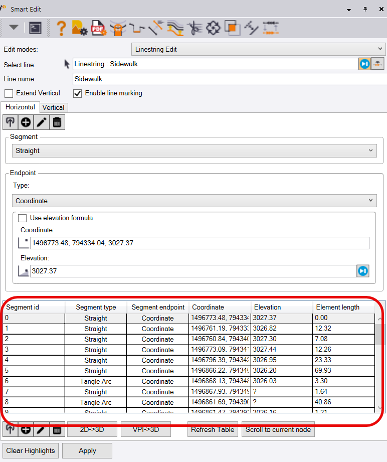
Smart Edit v2

Editing your data in 2D or 3D, including the majority of your data prep command needs including Break, Trim, Extend, Join, Fillet, Chamfer, Line Edit (vertical and horizontal), Insert Segment, Remove Segment, Fix Surface Model Flags, Dependent Line Editing, Elevate line by slope from a reference line, all in one command with hot key controls that allow you to rapidly move between edit modes and execute edits with limited mouse movements, mouse clicks, command executions, and on cursor information / assistance allowing you to keep your focus on the graphics not the dialog while working.
Horizontal Editor
Our new Horizontal Editor provides the ability to edit graphically or through use of arrow keys or navigation in the table view
Horizontal edits include
- Coordinate
- Point ID
- Station and offset
Vertical Editor
Our new vertical editor provides the ability to see all of your 3D nodes in a single table view (3D and VPI nodes), provides the ability to automatically add elevations to 2D nodes and convert VPIs to 3D nodes for any selected line, you can add VPIs using Elevation, Inbound Slope, Outbound Slope, Slope Slope or Offset Slope methods, all processes have been optimized for extremely rapid execution providing a single holistic process for editing in 2D or 3D views.

Vertical Mode provides
- Adding VPIs
- Editing VPIS
- VPI Modes include Elevation, Inbound / Outbound Slope, Slope Slope, Offset Slope, Vertical Curve and Vertcal Arc elements.
2D to 3D Conversion
Provide fixed elevations on 2D nodes with a single click on the 2D → 3D button
VPI to 3D Node Conversion
Convert VPI nodes into 3D nodes with a single click on the VPI → 3D Button
Video Overview - Coming Shortly
Line Marking Manager

The new Line Marking Manager provides all of the tools to manage your Line Markings in one place. If you select lines and run Line Marking Manager (CTRL F), the manager will automatically apply your preferred line marking settings to just the selected lines. If you run the Line Marking Manager without first selecting any lines, you will open the Line Marking Manager Command and have full access to all Line Marking settings and controls.
Overview Video
The Line Marking Manager brings easier use, more consistent control over which line markings are displayed and how to easily manage which lines they are applied to. The Line Markings controls are also integrated into the latest version of Smart Edit, allowing you to disable the Line Marking displays while editing linework if it is not required.
Label Slope / Label Station and Offset

We have been repeatedly asked to create a quick and easy to use Slope Labeling tool that generates a slope arrow as well as text that labels the slope between two locations on a surface, between two lines (CL / EOP) or between pairs of points. In addition we get asked to create quick ways to label Station and Offset for plans showing retaining walls or structures or piles etc. in relating to the highway alignment.
Label slopes provides both of these options
